Detailed 2015 Goldrush Notes, now updated to reflect adjusted ultra course for high heat expected. Please read carefully to prepare for the meet! A model map will be included in your packet.
Day 1
Veteran’s Park is one of the very first CTOC maps, probably first mapped before 2000. Willow Lane first mapped in 2004 by CTOC members. Last updates in 2014.
Day 2-3
Gold Rush first mapped in 2007 by Alexey Zuev. Last updates in 2014.
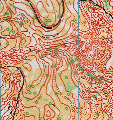
Gold Rush Hills sample
For those new to orienteering, the maps are more detailed than a normal topographic map. A quick guide at the OUSA website can be found here.
Tentative Course Statistics (final maps may change):
Friday Sprint: 1:5000, 2.5m contours
| Course | Distance | Climb | Controls |
|---|---|---|---|
| Blue/Red | 2.6km | 10m | 16 |
| Green/Brown/Orange | 2.3km | 10m | 16 |
| White/Yellow | 1.7km | 10m | 14 |
Saturday Ultra-Long: 1:10000, 5m contours
Mass start at 9am. 5 hour time limit.
| Course | Distance | Climb | Controls |
|---|---|---|---|
| Blue | 15.4km | 750m | 26 |
| Red | 12.3km | 600m | 21 |
| Green | 8.8km | 480m | 16 |
| Brown | 6.9km | 340m | 11 |
| Orange | 4.6km | 150m | 11 |
| Yellow | 4km | 75m | 11 |
| White | 3.1km | 60m | 9 |
Keep in mind there is no cell coverage in Idaho City, except for a small booster station right at the visitor’s center in town. You should not expect any coverage on the map while orienteering.
Sunday Middle: 1:7500, 5m contours
| Course | Distance | Climb | Controls |
|---|---|---|---|
| Blue | 4.3km | 240m | 23 |
| Red | 3.7km | 220m | 21 |
| Green | 3.0km | 150m | 17 |
| Brown | 2.6km | 150m | 14 |
| Orange | 2.5km | 120m | 13 |
| Yellow | 2.3km | 120m | 12 |
| White | 2.2km | 120m | 11 |